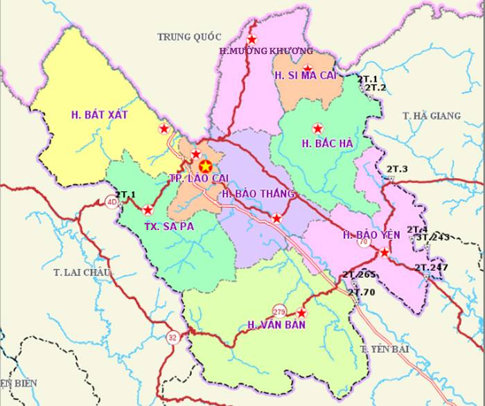
Geographical location - Topography - Administrative boundaries of Lao Cai province
Pursuant to Resolution No. 202/2025/QH15 dated June 12, 2025 of the 15th National Assembly on the arrangement of provincial-level administrative units, Lao Cai Province (new) was established on the basis of merging Lao Cai and Yen Bai provinces. Lao Cai Province (new) has a large economic scale, diverse natural resources, and an important geostrategic position in terms of national defense, security, and foreign affairs. The establishment of Lao Cai Province is a major policy, demonstrating the strategic vision of the Central Government in the process of arranging provincial-level administrative units to streamline the apparatus, maximize regional potential, improve governance efficiency and service quality for the people.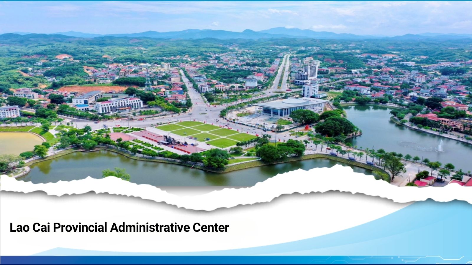
I. Natural conditions
1. Geographical location
Pursuant to Resolution No. 202/2025/QH15 dated June 12, 2025 of the 15th National Assembly on the arrangement of provincial-level administrative units. Lao Cai province was established on the basis of merging Lao Cai and Yen Bai provinces. After the merger, Lao Cai province (new) has a total natural area of 13,256.92 km2, ranking 8th out of 34 new provinces and cities in Vietnam, with a population of 1,778,785 people. Lao Cai province has 99 commune-level administrative units, including 89 communes and 10 wards.
Lao Cai province is a mountainous border province in the Northwest region, bordering the Northwest and Northeast regions. To the East, it borders Tuyen Quang and Phu Tho provinces; to the West, it borders Lai Chau province; to the South, it borders Son La province; to the North, it borders Yunnan province of the People's Republic of China with a common border of 182.086 km.
Lao Cai has an important position in the Northwest region, is the gateway for trade connecting Vietnam with the People's Republic of China through Lao Cai international border gate, and is also a bustling economic, cultural and trade center with provinces in the region and major economic centers in the country.
Located at the midpoint of one of the main economic corridors Kunming - Lao Cai - Hanoi - Hai Phong, with a modern infrastructure system including international railway, Noi Bai - Lao Cai expressway, important national highways such as National Highway 32, National Highway 70, National Highway 279, it has created favorable conditions and opportunities for Lao Cai to strengthen integration and economic and trade exchange, develop socio-culture, etc.
The administrative center of Lao Cai province is located in Yen Bai ward, 155 km from the center of Hanoi, with a favorable geographical location, creating conditions for the province to promote its role as a regional link with neighboring provinces such as Tuyen Quang, Phu Tho, and Lai Chau.

Lao Cai province has many famous places.
2. Terrain features
With rich and diverse terrain, including all the characteristics of highlands, lowlands, urban areas, rural areas and many developing sub-regions with distinct advantages, Lao Cai province has outstanding features.
High, rugged terrain
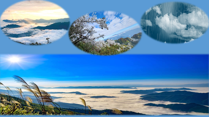
Lao Cai province has many high mountain ranges such as: In the West, there is Hoang Lien Son - Pu Luong range located between the Red River and the Da River, followed by the ancient Con Voi mountain range located between the Red River and the Chay River, in the East, there is a limestone mountain range located between the Chay River and the Lo River, plateaus and low valleys. In particular, Lao Cai province has Fansipan peak with an altitude of 3,143m, known as the "roof of Indochina", the highest in Vietnam, which is one of the important highlights, attracting tourists and contributing to the development of eco-tourism.
Strong differentiation: The altitude changes significantly, from high mountains above 2,000m to valleys and fields below 200m. The terrain is deeply divided, creating narrow valleys and steep mountain slopes.
Dense river and stream system: The Red River and Chay River systems originate from the People's Republic of China and thousands of kilometers of rivers, streams, and large and small lakes are not only a large source of surface water for the province but also create conditions for hydroelectricity and agriculture, but also easily cause flash floods and landslides.
Diverse landscape: There are high mountains, valleys, plateaus, and narrow plains interspersed with terrain levels, creating many distinct microclimates.
3. Climate characteristics
The climate of Lao Cai province is characterized by tropical monsoon, lots of sunshine and rain, and high temperatures. However, due to the complex terrain, Lao Cai province has a spatial climate differentiation, with lowland areas having a tropical climate and highland areas such as Sa Pa having a cold temperate climate, even with ice and snow.
The average annual temperature ranges from 18.9 to 23.90C (in Sa Pa alone 15.50C), the highest temperature is 40 to 420C, the lowest temperature is below 00C. The prevailing winds are the Northeast monsoon and the Southeast monsoon. There is a lot of rain but it is unevenly distributed, the average rainfall is 1,600 - 1,800 mm/year, the highest is up to 2,676 mm/year and the lowest is also 1,417 mm/year. Some microclimates in spring often have continuous drizzle.
The climate of Lao Cai province is characterized by tropical monsoon, lots of sunshine and rain, and high temperature.
* Main seasons of the year: Lao Cai climate has 2 distinct seasons.
- Cold season: From November to March of the following year, the cold lowlands last from 115-125 days. In the highlands, the cold season comes early and ends late, so it is longer than in the lowlands. In the highlands from 1,500m and above, there is almost no heat, the average temperature is stable below 200C, in some places it drops below 00C, fog, frost, snow and drought often appear at the beginning of the cold season (from December to January). In January - February, there is often drizzle in the southern region, typically in Yen Bai, Tran Yen, Yen Binh, Luc Yen, Mau A.
- Hot season: From May to October is the hot and humid period, the average temperature is stable above 260C, the hottest month is 29 - 300C. The hot season is also the rainy season, the average rainfall is from 1,200 - 1,600mm and is often accompanied by thunderstorms, strong gusts of wind, and lightning. Heavy rain on steep terrain often causes flash floods and landslides. The distribution of rainy days and rainfall depends on the terrain, gradually decreasing from East to West according to the province. Along the Red River valley, it gradually decreases from Southeast to Northwest, but in the Chay River valley, it gradually decreases from Northwest to Southeast.
* Rain mode
Lao Cai is located in a region with relatively large annual rainfall. According to data from the Lao Cai Provincial Hydrometeorological Station, the average rainfall at stations in 1 year is: Yen Bai 1,876.5mm; Luc Yen 1,942.6mm; Nghia Lo 1,417.3mm; Mu Cang Chai 1,730.5mm; Lao Cai 1,696.3mm; Sa Pa 2,676.6mm; Bac Ha 1,634.3mm; Bao Yen 1,602.6mm.
Rainfall distribution tends to increase from low to high areas, rainfall is unevenly distributed throughout the year. The rainiest months are July to August (with rainfall from 300 - 500mm/month), the rainiest months are December to February (with rainfall from 18 - 38mm/month).
Due to uneven rainfall between months, December, January, February is the dry season, the average rainfall is only 22.0 - 35.0mm/month (Sa Pa alone reaches 70.2mm), causing drought and water shortage for production and daily life. During the rainy season, in some places, the rainfall is too heavy such as Mu Cang Chai, Ta Xi Lang, Van Chan, Sa Pa, Bao Yen... causing floods, crop damage, damage to traffic and irrigation works.
* Humidity mode
According to meteorological data, the relative humidity is high, the annual average at the stations is as follows: Yen Bai is 86%; Luc Yen 86%; Nghia Lo 84%, Mu Cang Chai 81%, Lao Cai 86%, Sa Pa 87%, Bac Ha 87%, Bao Yen 86%. The difference in humidity between the months of the year in the regions in the province is not large, from 3-5%. The higher the altitude, the lower the relative humidity. There is a difference in humidity between the months, because humidity depends on rainfall and evaporation regime (temperature regime and wind regime), the month with the highest humidity at specific stations: Yen Bai and Luc Yen is January - April; for Nghia Lo is August - September; for Mu Cang is July - August, for Lao Cai, Sa Pa is February - May; for Bao Yen is March - June; for Bac Ha is May and November.
Lao Cai has relatively large annual rainfall and relatively high humidity, so the vegetation is green all year round, clearly showing the monsoon nature.
* Other weather phenomena
Hoarfrost: Appears mainly at altitudes above 600m, the higher the altitude, the more days with hoarfrost. Lowland areas in the Red River and Chay River valleys rarely appear.
Hail: Appears sporadically in some areas, some areas have many hailstorms such as: Mau A, Tan Dong, Mu Cang Chai, Yen Bai, Yen Binh. Hailstorms often appear at the transitional period of late spring, early summer, late autumn, early winter (March - May and October) and are accompanied by thunderstorms and local whirlwinds.
In addition, in high areas above 1000m, there is occasional frost and snow in mid to late winter.
* Climate zones
With its characteristic features, Lao Cai can be divided into two large climatic zones, with boundaries defined by the watershed of the high mountain range in the Northwest - Southeast direction, along the right bank of the Red River. Within the two large zones, there are five sub-zones with different climatic characteristics.
High Mountain
Western High Mountain
Eastern High Mountain
Northern Lowland
Southern Lowland
II. Natural resources
1. Land resources
Lao Cai province has diverse land resources, associated with the characteristics of highland terrain and climate with a total natural land area of 1,325,692 hectares, ranking 8th among 34 new provinces and cities of Vietnam. In which:
- Agricultural land area: 1,189,034 hectares, accounting for 89.7% of total area;
- Area of non-agricultural land: 97,059 hectares, accounting for 7.3% of total area;
- Area of unused land: 39,599 hectares, accounting for 3% of total area.
Lao Cai province's soil is highly fertile, very rich and diverse, including 10 soil groups with 30 main soil types, suitable for growing rice, crops, annual industrial crops and perennial industrial crops, with great potential in sustainable agricultural and forestry development and important for forest development and ecological environment protection, focusing on the following typical soil types: Alluvial soil, gray soil, red soil, humus alit soil, etc.
In particular, Lao Cai province has rare earth mines which are important raw materials for many high-tech fields such as electronics, photovoltaics, lasers, superconducting materials, luminescent materials, catalysts, and magnets.
2. Water resources
Lao Cai is located in a region with relatively large annual rainfall. According to data from the Lao Cai Provincial Hydrometeorological Station, the average rainfall at stations in 1 year is: Yen Bai 1,876.5mm; Luc Yen 1,942.6mm; Nghia Lo 1,417.3mm; Mu Cang Chai 1,730.5mm; Lao Cai 1,696.3mm; Sa Pa 2,676.6mm; Bac Ha 1,634.3mm; Bao Yen 1,602.6mm.
Rainfall distribution tends to increase from low to high areas, rainfall is unevenly distributed throughout the year. The rainiest months are July to August (with rainfall from 300 - 500mm/month), the rainiest months are December to February (with rainfall from 18 - 38mm/month).
Water resources of Lao Cai province are abundant, water quality is relatively good, and little polluted.
- Surface water resources: Lao Cai province has a dense river and stream system distributed quite evenly across the province with two large rivers flowing through, the Red River and the Chay River originating from China. This is a large source of surface water for the province with a water volume of tens of billions of m3/year and thousands of kilometers of large and small rivers and streams serving agricultural and forestry production and daily life, and is also a favorable condition for Lao Cai to develop medium and small hydropower projects.
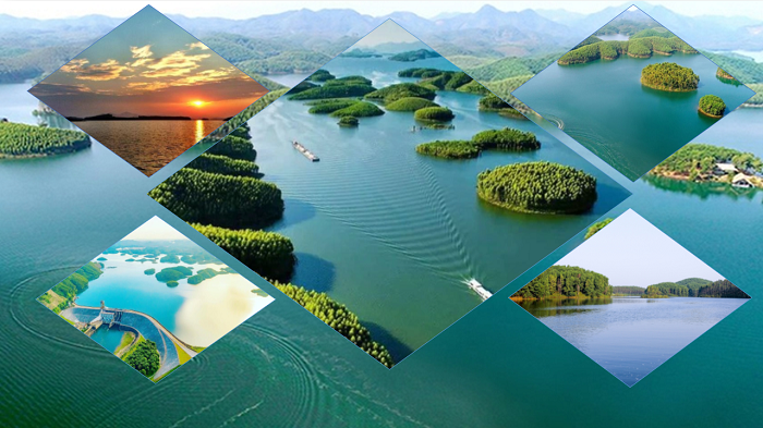
- Besides, Lao Cai province also has many lakes, lagoons, and dams, the largest of which is Thac Ba Lake with a surface area of 19,050 hectares, a length of 80 km, the widest point is 15 km, the depth of the lake is about 15 to 34 m, the total amount of water in the lake is up to 2.9 billion m3.
In addition, Lao Cai province also has large reserves of groundwater and mineral water. According to geological and hydrological documents, groundwater and mineral water are distributed at a depth of 20-200m underground. However, groundwater is unevenly distributed in different geological formations. The groundwater level varies in some places, only a few meters, and in some places, it is only a few dozen meters.
- With the diversity of terrain and cool high mountain weather but containing hot mineral veins that have created mineral springs, hot water is mainly concentrated in the eruptive rocks. Hot water has a temperature of 30 - 500C. Total mineralization is 1 - 5g/l, water belongs to the calcium - magnesium sulfate group with high content of Silicon and sulfur, can be used for nursing and treatment. Hot mineral water points are concentrated in communes such as Tram Tau, Van Chan, Tu Le, Ban Hoc, Ban Bon, Ban Mac Bat Xat and so on.
In general, Lao Cai province's water resources are abundant, the water quality is relatively good, and there is little pollution. Therefore, they are of great value in socio-economic development and daily life. If exploited and used properly, they will meet the water needs for agricultural production, forestry, industry, daily life and many other fields.
3. Forest resources
Lao Cai province has rich forest resources, playing an important role in socio-economic development and ecological environment protection. With a total natural land area of the whole new Lao Cai province of 1,325,692 hectares, the forested land area including planted forests is 865,060 hectares. Of which:
- Natural forest: 473,223 ha;
- Planted forests: 391,837 ha (specifically planted forests: 338,883 ha; planted area not meeting forest criteria: 52,954 ha).
Forests are classified into three types of forests.
- Special-use forests: 92,617 hectares;
- Protective forests: 289,200 hectares;
- Production forest: 436,703 ha.
- Other purposes: 46,540 hectares
The forested land area that meets the standards to calculate the forest cover rate of Lao Cai province is 812,106 hectares; The total coverage rate of the province is 61.5%, an increase of 1.8 percentage points compared to 2020.
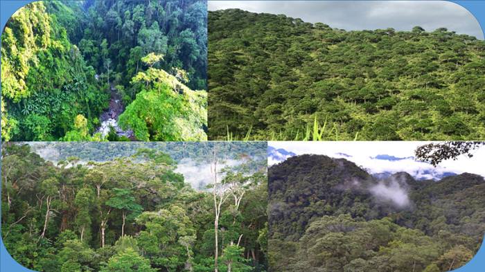
Lao Cai owns many types of valuable forests, diverse ecosystems, including special-use forests, protective forests and production forests. The flora is rich with many species of precious wood, medicinal herbs, bamboo, and endemic animal and plant genetic resources, with high conservation value. In addition to the role of regulating climate, protecting water resources, preventing erosion, Lao Cai forests also have great potential for sustainable forestry development, associated with ecotourism and nature conservation, including special-use forests such as: Hoang Lien National Park with an area of 28,498 hectares, Hoang Lien Nature Reserve with an area of 24,933.42 hectares; Bat Xat Nature Reserve with an area of 18,637 hectares; Na Hau Nature Reserve with a total planned area of 16,950 hectares.
These are large, contiguous forests with high biodiversity, containing many endemic and rare species of flora and fauna that need to be protected. The flora of the special-use and protective forests of Lao Cai province is quite rich and diverse, distributed in many different habitats such as grasslands, shrubs, and tree species on soil and rocky mountains.
The forest structure has not been broken, the canopy is clearly divided: The highest layer is large trees that rise up discontinuously, mainly species such as: Chò châu, Dổi, Trâm...; the middle layer is the ecologically dominant layer, the canopy of the forest is continuously almost the same height, belonging to evergreen species such as: Gội, De, Dẻ...; the lower layer is divided into many layers of different heights, mainly small shade-loving trees; the fresh carpet layer is mainly shrubs, ferns, wild Areca... Currently, the natural forest has over three thousand species of higher vascular plants. The most diverse phylum is Magnolia, with 193 families and 3,326 species, rare timber species such as: Lát Hoa, Pơ mu...
The fauna in the reserve is quite rich and many rare species are still preserved and conserved. There are 20 rare species listed in the Vietnam Red Book and the World Red Book, accounting for 2.3%, 19 species listed in the appendix of the CITES Convention, and 22 endemic species typical of the Hoang Lien Son highlands.
With abundant natural forest resources, the quality and value of forests and forestry economy of Lao Cai province have been improved. The province's key production areas have contributed to promoting economic restructuring and increasing people's income, forming specialized agricultural production areas with large scale bringing high value such as: mulberry growing area of 1,500 hectares, fruit tree area of 23,831 hectares, tea area of 16,046 hectares, cinnamon area of 144,200 hectares; medicinal herbs of 8,875 hectares,... many processed products bring high economic efficiency, many products have export value.
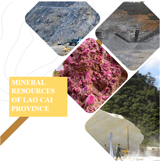
4. Mineral resources
Lao Cai province has quite rich and diverse mineral resources with many different types of minerals. Among them, there are minerals with large reserves and high value such as: apatite over 2.5 billion tons, metal minerals (iron, copper, lead, zinc, gold, manganese,...), coal fuels of all kinds (coal, brown coal and peat...), non-metallic minerals (industrial minerals and construction materials: kaolin, feldspar, quartz, graphite, talc, molybdenum, kaolin - feldspar, white limestone, stone for construction materials, sand, gravel...), rare minerals (gems of all kinds)...
III. Economic potential
1. Advantageous economic sectors
With a favorable geographical location, rich natural resources, abundant human resources, open and attractive investment attraction policies, economic potential is an important condition for Lao Cai to welcome investors to cooperate and develop together.
* Industrial potential
Lao Cai province has quite rich and diverse mineral resources with many different types of minerals. Among them, there are minerals with large reserves and high value such as: apatite over 2.5 billion tons, metal minerals (iron, copper, lead, zinc, gold, manganese,...), coal fuels of all kinds (coal, brown coal and peat...), non-metallic minerals (industrial minerals and construction materials: kaolin, feldspar, quartz, graphite, talc, molybdenum, kaolin - feldspar, white limestone, stone for construction materials, sand, gravel...), rare minerals (gems of all kinds).
Many types of minerals are being exploited for deep processing in Lao Cai such as apatite, copper, lead, zinc, graphite, rare earth ore selection, white limestone mining and processing with an output of 1.5 million tons/year; rotary kiln cement reaching 1.8 million tons/year...
Lao Cai is considered a province with great potential for hydropower development, including Thac Ba Hydropower Plant, the first hydropower plant built in Vietnam with the support of the Soviet Union (now Russia), playing an important role in providing electricity and economic development for the North with an initial capacity of 108 MW, now upgraded to 120 MW.
* Agricultural, forestry and fishery potential
Lao Cai province has a spatial climate differentiation, with lowland areas having a tropical climate and highland areas having a cold temperate climate. With great potential for land and forests, this is a great advantage in the development of agriculture, forestry and fishery.
With the advantage of subtropical climate characteristics in the highlands, cool in summer, cold in winter, very suitable for temperate crops such as apples, pears, peaches, plums, roses, lilies, orchids, medicinal plants, off-season vegetables, cold-water fish farming such as salmon, sturgeon, the products of this region all have specialties that lowland provinces do not have, this is a potential, a unique strength of Lao Cai province.
With low areas, typical of hot and humid tropical climate, suitable for growing tropical fruit trees such as pineapple, banana, orange,...
With great potential of forests and forest land, Lao Cai has advantages to develop the agricultural and forestry sector associated with raw material areas: afforestation and processing of paper, pulp, and artificial boards; especially developing raw material areas for growing and processing cinnamon, tea, tobacco, and coffee; growing and processing cassava and fruits; growing and processing aquatic products while developing livestock, poultry, and warm-water aquatic products (catfish, spotted catfish, giant freshwater prawn).
Agricultural, forestry and fishery production in Lao Cai province ensures the seasonal schedule, implements biosafety and organic production; disease prevention in livestock and poultry, forest protection and development are closely monitored and directed, aquaculture areas are maintained and stabilized. With the advantages and potentials of agriculture, forestry and fishery, Yen Bai province has great potential for developing agricultural, forestry and fishery economy associated with building new, modern and sustainable rural areas.
* Trade and economic potential of border gates
Lao Cai province has a pair of Lao Cai - Ha Khau international border gates (railway and road) with 3 customs clearance points: Lao Cai international station, road bridge over Nam Thi river, road bridge over Red river (the connecting point between Hanoi - Lao Cai highway (Vietnam) and Ha Khau - Kunming highway (China) is an important bridge on the Kunming - Lao Cai - Hanoi - Hai Phong economic corridor; is the gateway of Vietnam and ASEAN countries.
The center of the North-South Corridor in the cooperation of the Greater Mekong Subregion (GMS) countries with the Southwest market - China. Lao Cai International Border Gate is the only border gate in the North of Vietnam located in the heart of a provincial city, with a full service system of a class II urban area as well as commercial services of transportation, warehousing, logistics, cargo inspection, and ICD ports.
Since 2001, the border trade fair has been held annually between Lao Cai (Vietnam) and Hekou (Yunnan - China), attracting a large number of domestic and foreign enterprises to participate.
* Tourism potential
Lao Cai is a mountainous province with diverse natural landscapes, a clean ecological environment and many famous scenic spots, which are potential for investment in building eco-tourism and scientific research sites.
- Sa Pa is considered as "mountain muse", attracting tourists by terraced fields stretching like silk strips winding around the mountainside, with Fansipan peak, the highest mountain in Vietnam, considered as the roof of Indochina at 3,147.3 m high, located in Hoang Lien Son range. The mountain is formed from ancient metamorphic rocks, granite and sedimentary rocks with a diverse ecosystem and many rare species of animals and plants. The mountain has a 3-wire cable car line nearly 6,300 m long, achieving a Guinness record (2016).
- Thac Ba Lake scenic tourist area has an area of over 19,000 hectares, with over 1,300 large and small islands surrounded by majestic mountains and many interesting caves such as: Thuy Tien cave, Xuan Long cave, Bach Xa cave, Cao Bien mountain, Chang Re mountain and is called "Ha Long Bay on the mountain". This place has the potential to develop large-scale eco-tourism and is planned as a national tourist area.
- Thac Ba Hydropower Plant is the first hydropower plant built in Vietnam with the support of the Soviet Union (now Russia) with an initial capacity of 108MW, now upgraded to 120MW.
- Mu Cang Chai terraced fields ranked as a special national monument with a protected area of nearly 853 hectares and praised by the American press as having the most spectacular and exquisite beauty in the world.
- Hoang Lien National Park is recognized as an ASEAN Heritage, preserving rich flora and endemic fauna; Na Hau Nature Reserve; Che Tao Species and Habitat Conservation Area.
In addition to Sa Pa, Lao Cai also has some places with cool climate all year round such as Bac Ha, with mysterious ancient stone beach; Dam Van Hoi Lake; hundreds of years old San Tuyet tea trees, hot mineral springs are distributed mainly in the western region of Van Chan, Tram Tau, Sa Pa communes and Nghia Lo ward, Trung Tam ward, Cau Thia ward with mineral content of 1-5g/l, capable of curing diseases when treated with toxins.
Lao Cai province also has many ranked historical relics. The whole province has 56 intangible cultural heritages, of which 3 heritages have been listed by UNESCO as representative intangible cultural heritage of humanity; 54 national intangible cultural heritages, many long-standing cultural and historical relics serving famous cultural and spiritual tourism such as: Bao Ha Temple, Thuong Temple, Doi Co Temple, Dong Cuong Temple, Nhuoc Son Temple, Hac Y Temple - Dai Cai Temple Area, Thac Ba Temple, Huong Thao Cave, Ngoc Am Pagoda... and nearly 50 ethnic groups living with unique cultural features from writing, costumes, house designs, culinary culture of the ethnic groups in Mu Cang Chai, Tram Tau, Nghia Lo, Bac Ha, Y Ty, Nghia Do... are exploited and promoted effectively in association with the development of unique tourism products and rich intangible cultural treasures such as xoe dance, khen dance, love duet singing... are factors attracting domestic and foreign tourists.
From geographical advantages, tourism resources have helped Lao Cai develop many types of tourism such as: Cultural tourism, resort tourism, eco-tourism, sightseeing tourism, sports tourism, scientific research tourism.
With unique natural, cultural and social advantages for tourism development that not every locality has, Lao Cai has many favorable factors to become an attractive tourist destination in the Northwest region.
After the merger, Lao Cai province is expected to become the economic, cultural and tourism center of the Northwest region, thanks to the effective exploitation of its potential resources, geographical location and human resources./.