History
Lao Cai is an ancient land, the topography was formed 50-60 million years ago, during the last batch of paint, crust twisted, broken. The ancestors of Lao Cai indigenous people at that time were quite concentrated in the hills along the Red River, Chay River, Mi and Nhu gates. In the early days, the tribes that defined the sovereignty boundary line, under the reign of Hung Vuong in Tan Hung, were one of the 15 ministries of Van Lang State. In Au Lac period, the eastern and southern regions of Lao Cai belonged to the Tay Vu tribe, and a part of the west and north of Lào Cai now belonged to smaller tribes that refused to tame Lac Viet. During the Northern domination, it was originally a territory of Tay Vu and Giao Chi districts. Later it belonged to Tan Hung district, Giao Chau land (Tay Tan period), later Chau Dan land, Chu Quy belonged to Giao Chi (Tuy period), Lam Tay Chau was changed, Duc Hoa Chau belonged to An Nam government (Duong period), 679). In the reign of Dinh, Ly, Tran, Le, there were many changes in place names ... By the Nguyen Dynasty, the land of Lao Cai was mainly belonged to the land of Chau Thuy Vy, Chau Van Ban, part of Chieu Tan and one a small part of Luc Yen continent belongs to Quy Hoa government. Up to this point, the name of Lao Cai has not been established.
According to the researchers, the name Lao Cai is pronounced from Lao Nhai and is called for quite a long time. When making maps, the French wrote Lao Cai as Lao Kay. The term Lao Kay was used by the French in documents and seals. But in communication and folk people still called Lao Cai. After the liberation of Lao Cai (November 1950), it was agreed to be called Lao Cai to this day.
After conquering Lao Cai (March 1886) and upon completing the military pacification, the French colonial government ruled Lao Cai territory under the military regime. On 7/01/1899, the IV army was established to include Yen Bai Military Region and Lao Cai Military Region. On July 12, 1907, the governor-general of Indochina issued a decree to abolish the army IV of Lao Cai, changing from military to civilian rule to establish Lao Cai province. From here the place name of Lao Cai is determined on the map of Vietnam.
Experiencing ups and downs of history, Lao Cai geography also has many changes. Regarding administrative landmarks, through many splits:
- Establishing Lao Cai province (July 12, 1907), the land of Chau Thuy Vy on the right bank of the Red River merged with Chieu Tan, still named Chau Thuy Vy. Since then, Chieu Tan no longer exists. The land of Thuy Vy district on the left bank of the Red River was split to form Bao Thang. Lao Cai province consists of two continents Thuy Vy, Bao Thang and agents Muong Khuong, Phong Tho, Bat Xat, Bac Ha (Pa Kha) and Lao Cai town, including 855 villages, 6,812 households, 39,099 people, with 11 main ethnic groups: Hmong, Dao, Tay, Giay ... of which H'mong people account for 26.56%, Dao 22.41%, Tay, Giay 20.77%, Kinh 4.52%, Nung 7.33%, Thai 9.25%, U Ni 2.48%, overseas Chinese 4.44%, the rest are other ethnic groups.
- After the first liberation of Lao Cai province, Lao Cai was divided into 8 districts: Bac Ha, Muong Khuong, Ban Lau, Bao Thang, Sa Pa, Bat Xat, Phong Tho and Lao Cai town.
- On 13/5/1955, moved Phong Tho district to Thai - Meo autonomous area (now Phong Tho is Lai Chau city and 2 districts of Phong Tho and Tam Duong in Lai Chau province).
- On December 27, 1975, at the second session of the 5th National Assembly, a resolution to merge the three provinces of Lao Cai, Yen Bai and Nghia Lo into a new province was named Hoang Lien Son.
- On 17/4/1979, expanding Lao Cai town on the basis of merging Cam Duong town; Si Ma Cai and Bac Ha are merged into one administrative unit named Bac Ha district.
- On August 12, 1991, the 9th Session of the 8th National Assembly issued a Resolution dividing Hoang Lien Son province into Yen Bai and Lao Cai provinces.
- On October 1, 1991, Lao Cai province was re-established, based on Lao Cai (old) land and added three more districts: Bao Yen, Van Ban (of former Yen Bai), Than Uyen (of former Nghia Lo). ) including 8 districts and two towns.
- On June 9, 1992, the Council of Ministers decided to divide Lao Cai town into Lao Cai and Cam Duong towns.
- On December 30, 2000, Bac Ha district was split into Si Ma Cai and Bac Ha districts.
- On January 31, 2002, the Prime Minister issued a Decree to merge Lao Cai and Cam Duong towns into Lao Cai provincial town.
- On January 1, 2004, Than Uyen district was split into Lai Chau province (new).
- On November 30, 2004, the Prime Minister issued Decree No. 195/2004 / ND-CP on establishing Lao Cai city in Lao Cai province.
- On October 30, 2014, the Prime Minister signed a worker in Lao Cai city which is a class-2 city under the province.
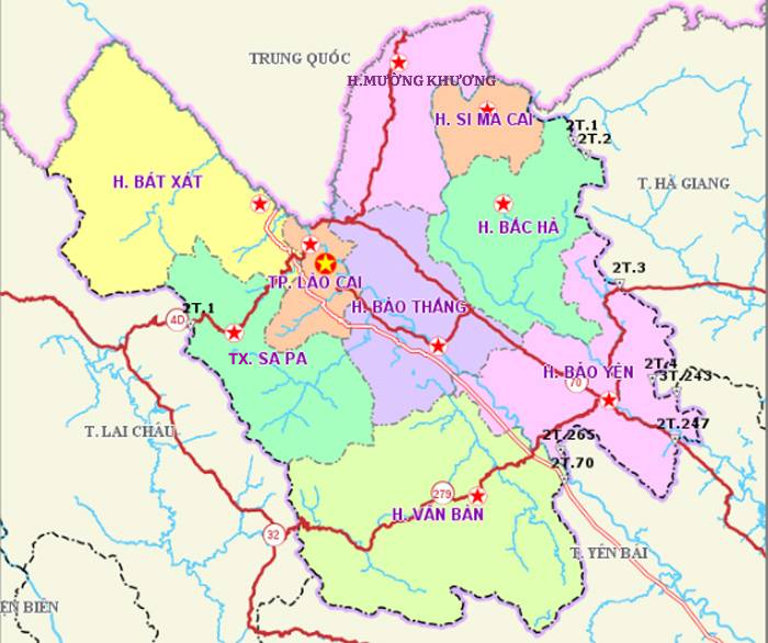
Currently, Lao Cai province includes Lao Cai city and 8 districts: Bao Thang, Bao Yen, Bac Ha, Si Ma Cai, Muong Khuong, Sa Pa, Bat Xat and Van Ban.